News Summary
A significant rainstorm is expected to hit Southern California this week, bringing heavy rainfall and potential flash floods. Residents should prepare for varying rain amounts starting Wednesday, with the main storm arriving Thursday. Areas could see 1 to 4 inches of rain, raising concerns about mudslides in regions affected by wildfires. Additionally, the Sierra Nevada mountains anticipate heavy snowfall. Authorities urge caution on roads, especially in recent burn areas, while schools have taken precautionary measures in Malibu. Stay safe and be prepared for changing weather conditions.
Southern California Faces an Incoming Storm: What to Expect!
Get ready, Southern California! A big rainstorm is headed your way this week, and it’s going to pack quite a punch. According to the National Weather Service, this could be one of the strongest storm systems we’ve seen all winter. So, it’s time to grab those umbrellas and maybe some hot cocoa!
Pre-Storm Rain Ahead
Starting Wednesday morning, the region can expect some light rain as a prelude to the main event. This initial round of rain will likely come in waves with breaks in between, making it a perfect time to huddle underneath that cozy blanket. Rain amounts on Wednesday could range from ¼ inch to 1 inch, especially for areas further east or south, where an inch seems to be on the more generous side!
The Big Downpour on Thursday
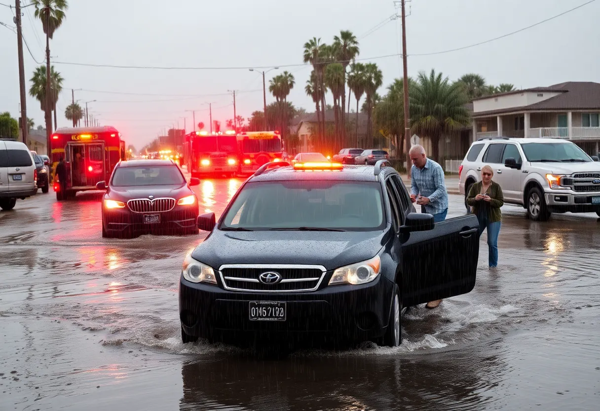
But hold on! The main storm is set to hit on Thursday, and it could bring some serious rainfall to the area. Expect a range between 1 to 4 inches of rain across Southern California over a 36-hour period. Foothill communities might see even more, with possible totals reaching from 2 to 4 inches. This rainfall poses the risk of debris flows and mudslides, particularly in regions affected by recent wildfires. Thankfully, the threat of flooding is considered low for the first round, but don’t let your guard down!
Winter Wonderland in the Mountains
If you’re a fan of snow, the Sierra Nevada mountains could be your happy place this week! Some areas might see a whopping 5 feet of snow as the storm blankets the peaks, making it a winter wonderland. Just remember, though, that heavy snowfall can also impact travel, so check your routes if you plan on heading up there.
What to Prepare For
As the storm sweeps through, you might experience thunderstorms, especially on Thursday, so keep those weather apps handy! Showers are expected to linger through Friday as the storm starts to move out, so it’s best to be prepared for a moody weather weekend.
Flash Flood Watches in Effect
One of the bigger concerns will be flash flood watches, especially in recent burn areas starting Thursday afternoon. Some damage has already been reported in the region, with mudslides leading to closures and impacting driving conditions. The Los Angeles Fire Department noted instances of “debris flow” and “vehicles in the mud,” primarily in Woodland Hills. Stay safe out there if you are on the roads!
Impact on Daily Life
For students and families, be aware that the Santa Monica-Malibu Unified School District has closed schools in Malibu due to unsafe road conditions, but schools in Santa Monica remain open. If you have kids in school, keep an eye on announcements.
Driving Caution
Just recently, snow in Tejon Pass caused a part of Interstate 5 to close on Sunday evening, though it has since reopened. In another area, Canyon Boulevard at Pacific Coast Highway was blocked off after Topanga Creek overflowed, scattering debris along the roadway. Always check your routes and allow for extra travel time if you must go out.
The Calm Before the Storm
As we gear up for the storm, Los Angeles and Orange counties are seeing temperatures around 60 degrees during the day and dropping to about 46 degrees at night. This mixed bag of clouds and sunshine won’t last long, so enjoy it while it’s here!
This week is undoubtedly going to be interesting, but with a little preparation and some good weather attitudes, we’ll get through it together. Stay warm, stay safe, and let’s hope the rain brings a fresh start for our thirsty gardens and landscapes!
Deeper Dive: News & Info About This Topic
- KTLA News
- Wikipedia: California
- The New York Times
- Google Search: Southern California Storm
- San Francisco Chronicle
- Google Scholar: Storm Impact California
- ABC7 News
- Encyclopedia Britannica: California Weather
}